Focus for today:
Photo transects: A picture is worth a thousand data points!
Target Key Stage:
Key Stage 4 – Double Award Applied Science: Unit 1, Developing Scientific Skills, Carrying out practical tasks (recording and analysing scientific data) / Unit 3, Science at work, monitoring living organisms.
Key information:
A picture is worth a thousand data points! For the Living Oceans Foundation expedition team, this is precisely the goal >> to capture images of the benthic habitat along the Farasan Islands. Each ground truthing team completes a number photo transects along the bottom of the ocean, effectively capturing the array of species present at each site. To create a photo transect, a diver places a 50m tape onto the seafloor and uses a measured length of pipe to take 1m long digital photos of the substrate.
While the corals remain still, it is very tricky work, as the diver must maintain a steady distance and angle from the coral while fighting any current or wave conditions. Once the diver has completed the transect line, the multiple digital photographs can be ‘stitched’ together to create one long, 50m image of the seafloor. These transect lines can be used by scientists to create a multi-dimensional model of the benthic habitat of the Farasan Islands. In addition, coral and sponge species can be identified from the photographs in order to determine the relationships between species and their interaction with the environment at each site. During processing, each genus and sometimes species is given a specific color with which to be identified.
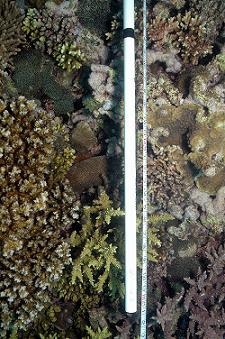
A photo along the transect
During this expedition, the focus is mainly on coral species, but other organisms have been noted and recorded. For our purpose, a coral expert can then identify and color code each of the corals on the substrate until the entire transect line is a mosaic of assigned colors. After the photos have been completely assigned their color codes, this is called ‘digitization’, the transect can be analyzed for percent cover by each species on the substrate as well as for any number of other relationships. Relationships between different sites can also be easily determined through statistical analysis.
Over 50 transects have been completed thus far-that’s over 2,500 m of data!
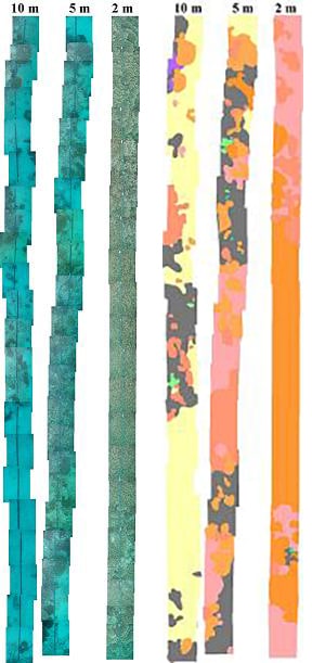
‘Stiched’ transect photos/’Digitised’ transects
Question for students/food for thought:
What is another type of environment where photo transects could be used? If a diver was not careful in taking their photos, and the images were at different sizes/angles, what effect do you think this could have on the data?
Additional information:
There are other methods for capturing the percent cover of the benthic substrate. One of these alternative methods is the use of video to create transect lines. Similar to photo transects, a diver places a measuring tape along the seafloor, then videotapes along each side of the tape to record the organisms growing there. During analysis, the film is replayed on a television screen, pausing to view each frame. A mask is placed over the television screen, leaving only five random holes within view. The substrate in each of these five holes is then identified and that information is entered and analysed for percent cover on the substrate.