Focus for today:
The importance of post-survey data management.
Target key stage:
Key Stage 4: Double Award Applied Science; Unit 1 – Developing Scientific Skills; Carrying out practical tasks (recording and analysing scientific data).
Key information:
This is a 3 week long expedition and within that time the scientists will be collecting as much data as possible. Most of the day-time is spent collecting data but it is very important to keep an accurate record of where and when all data was collected. Imagine what would happen if we went home and couldn’t remember which dive related to which site! Each researcher dedicates a few hours of time every evening to post-survey data management in order to manage their data on a day to day basis – the evenings are a particularly busy time on the ship as the researchers gather and label all their data before the next day of surveying.

Preparing a survey line
The benthic (sea bed) survey team are using a ‘photo transect’ method for their surveys. The data that is generated is a series of approximately 100 photographs along a 50 m long section of the reef at a specific water depth. At the end of photographing the transect line, the diver takes a photograph of his/her depth gauge so that there is a photographic record of the depth of the survey within the series of reef transect photographs. After the dives, post-survey data management for the benthic team consists of downloading the photographs from the digital cameras onto laptop computers and a separate file is made for each transect. Each data file is labelled with the site name, date and time of the survey and the depth at which the transect was taken so that there is no confusion between surveys.
The fish survey team also have much post-survey data management to be completed after each dive. During their dives the surveyors record fish species and size onto a piece of underwater paper attached to a clipboard (they use normal pencils underwater!) However, because fish are swimming all the time, the divers do not have time to write down the full scientific name of each individual. Instead each diver uses a personal coding system for recording the species they observe.
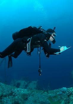
Fish transect – survey
Sometimes it is necessary to makes notes about the colours and patterns on the fish. After the dive, these codes and notes need to be deciphered and compiled into a spreadsheet. Some fish species may be difficult to identify underwater and in this case, a digital photograph is taken and fish reference books are used to identify the individual once back onboard the ship. All fish survey recording forms are labelled with the site name, date and time of survey and water depth.
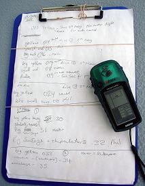
Data board and GP
Using a hand-held GPS unit, exact positions (i.e. latitude and longitude) are taken for the start and end points of each transect line. Whilst out on the boats, each point is marked with a code called a ‘waypoint’. Each waypoint is written down on a piece of paper on a clipboard. Once back on the ship, these waypoints and their corresponding latitude and longitude are catalogued in a spreadsheet, along with the date and depth of each survey.
Question for students/food for thought:
How can you apply post-survey data management techniques to scientific experiments that you conduct? In previous experiments, did you manage your data adequately or can you think of ways to improve your data management techniques for future experiments?
Additional information:
The researchers have already collected a lot of data. In the first week of the expedition we have conducted 24 benthic (seabed) photo transects (that’s 2,400 photos!) and 12 fish surveys at water depths ranging between 4 and 17 m.
Unfortunately we have been experiencing internet connectivity problems since last night. We have been informed by our Internet Service Provider (based in Turin, Italy) that this is due to storm actiivity in their region. We are now getting better connectivity, and are hoping it remains stable. Apologies for late postings….
And finally – today we observed two species of coral that are not recorded in the northern Red Sea, Physogyra and Diploastrea! This was particulalry exciting for the coral biologists onboard. An article about biological zonation will appear on the website soon….