
search-icon
Where in the World is the Golden Shadow?

Yesterday you were presented with a number of scenarios for the Golden Shadow to avoid Tropical Storm Emily.  Hopefully you spent some time considering the ship’s options for dodging the storm and steering clear of its predicted path.  Assuredly, the ship’s Captain went through a similar process.  In addition, he consulted with the Living Oceans Foundation’s Executive Director, Captain Philip Renaud.  At length, a decision was reached and if you decided on Option 2, which was to head west, then you agreed with the ship’s Captain.

Heading west into the Gulf of Mexico was the only option available to put the ship well out of the path of Tropical Storm Emily, but also moves us further from our ultimate destination: the Inaguas in the southeastern Bahamas.  In order to allow enough time for the storm to pass by the Inaguas (now predicted to happen on Friday), the ship will actually travel around the western tip of Cuba and then follow an easterly course towards the Inaguas along Cuba’s southern coast.  The Golden Shadow will be safely in the lee of the island of Cuba throughout the voyage and will be positioned to arrive in the Inaguas on Saturday once the storm is well north of the region.  Congratulations if you came to this same conclusion – ever considered a maritime career?
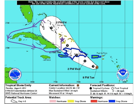
 

Planned route for the Golden Shadow to avoid Tropical Storm Emily


To pass time during our detour around Tropical Storm Emily, the research team has been preparing dive gear, data sheets and sampling materials.  Dr. Sonia Bejarano (Living Oceans Fellow) and Indira Brown of the Bahamas Department of Marine Resources, have been furiously building wire cages that will keep herbivorous fish away from tiles that Sonia will deploy to measure algal growth on the reef.
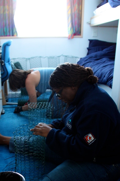
 

Dr. Sonia Bejarano (Living Oceans Fellow) and Indira Brown of the Bahamas Department of Marine Resources build fish exclusion cages


Others on board are brushing up on reef species identification skills to help with AGRRA surveys.  AGRRA stands for Atlantic and Gulf Rapid Reef Assessment Program and is an important component of the Global Reef Expedition in the Atlantic Ocean.   The program’s goal is to work across international borders to determine the regional condition of reefs in the Western Atlantic and Gulf of Mexico.  Scientists and resource managers can then use this baseline data in their efforts to protect coral reefs throughout the project area. The AGRRA method is just one component of the Global Reef Expedition’s research plan, as described in previous blogs.
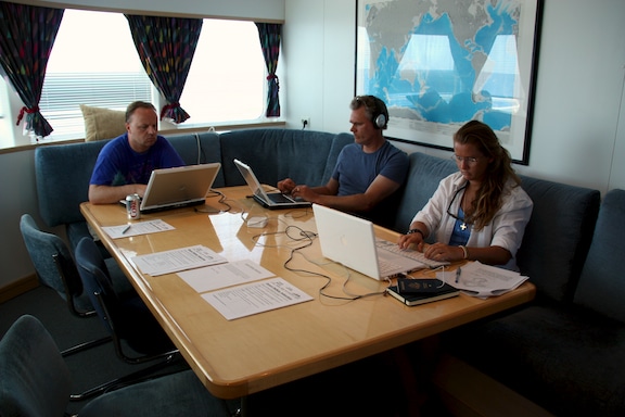
 

Global Research Expedition team members working and brushing up on reef species identification skills in the staff mess while underway
Global Reef Expedition team members at work in the staff mess while underway


Written by Kit van Wagner

(Photo/Images by: 1 NOAA National Hurricane Center; 2 – 3 Kit van Wagner)

To follow along and see more photos, please visit us on Facebook! You can also follow the expedition on our Global Reef Expedition page, where there is more information about our research and our team members.
Related Posts

2025-2026 B.A.M. Student Voices

Throughout the Bahamas Awareness of Mangroves (B.A.M.) and Jamaica Awareness of Mangroves in Nature (J.A.M.I.N.) programs, we evaluate each phase of the mangrove education and restoration process to better understand how students are learning, growing, and connecting with their coastal environments.

Before the programs begin, students share what they already know about mangroves and how they feel about them. As the program progresses, we continue to gather feedback to see how their knowledge evolves from identifying mangrove species and understanding food webs to recognizing the role mangroves play in coastal protection and climate change mitigation.

But the surveys go beyond science content.

We also ask students…

Read More

Ten Years of B.A.M.: Rooted in Partnership, Growing in Purpose

Ten years ago, the Bahamas Awareness of Mangroves (B.A.M.) program began with a simple but meaningful commitment: to connect Bahamian students with the mangrove ecosystems that shape and protect their island home.

Since 2015, B.A.M. has been implemented in partnership with Friends of the Environment, whose dedication to environmental stewardship in Abaco has made this program possible year after year. Together, we have worked alongside Patrick J. Bethel High School and Forest Heights Academy to bring hands-on mangrove science into classrooms and out into the field.

What makes ten years remarkable is not just longevity — it is consistency…

Read More
Privacy Overview

This website uses cookies so that we can provide you with the best user experience possible. Cookie information is stored in your browser and performs functions such as recognising you when you return to our website and helping our team to understand which sections of the website you find most interesting and useful.  You can view our complete Privacy Policy here.

Strictly Necessary Cookies

Most of our cookies are used to improve website security and reduce spam. These cookies should be enabled at all times. They also enable us to save your preferences for cookie settings.

3rd Party Cookies

This website uses Google Analytics to collect anonymous information such as the number of visitors to the site, and the most popular pages. Keeping this cookie enabled helps us to improve our website.