Today was our last day surveying and conducting education programs in the Niuas. It has been a successful journey, but now we are headed back to mainland Tonga – a 27 hour transit.
Traditionally in Tonga, vessels were a means of traveling between islands, fishing, trade, exploring, and migrating to new areas. With modern technology it’s rare to see these vessels in operation.
History of Polynesian Navigation
Oceania: Micronesia, Melanesia, and Polynesia are all subregions of Oceania. From 3000-1000 BCE, the Austronesian language spread into the western edges of Micronesia and into Melanesia. Archeological records show that northwest Melanesia (today known as Taiwan) became inhabited by a distinct culture known as Lapita. From 1300-900 BCE, the Lapita culture spread around 3,730 miles (6,000 km) reaching Samoa and Tonga. Tonga is thought to be colonized by the Lapita around 1500-1000 BCE. Samoa and Tonga is where the distinctive Polynesian culture developed.
Polynesian Navigation: These early Polynesians were known for their seafaring skills and intricate knowledge of navigation passing it down through oral history from generation to generation. They are believed to be the first to navigate the open ocean. The distances between islands in Polynesia were much greater and the ocean conditions were much harsher than in Micronesia and Melanesia. Because of this, the Polynesian’s highly developed navigation system included an understanding of many different factors including observation of the stars, ocean currents and swells, wind and cloud patterns, the rise and fall of the sun, colors of the sea and sky, weather, seasonal information, and the migration of animals such as birds. Polynesian navigators relied heavily on their senses which acted more as navigational tools.
Polynesians traveled on double-hull canoes connected by two crossbeams with a central platform that laid over them. The triangular sails were made out of specialized woven mats (see this blog for more information: Ancient Art of Tonga). These canoes could be as large as 50-60 feet in length and carry two dozen people, food, livestock, and crop materials.
Polynesians traveled thousands of miles exploring and settling on different islands. Seafarers traveled east to the Marquesas, Society and Marshall Islands, Hawaii, and Easter Island; south to New Zealand, and north as far as Tuvalu. This region became known as the Polynesian Triangle, and it’s a simple way to define Polynesia. It extends to the three corners of Easter Island, Hawaii, and New Zealand.
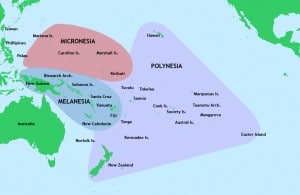
Map of Oceania. The triangle represents the region within which Polynesian navigation flourished.
Tongan Canoes
Pōpao
The pōpao is the Tongan outrigger canoe, one of the smaller vessels of Polynesian navigation. The canoe’s hull is carved out of a tree trunk and sticks (sometimes made out of bamboo) are usually used for the crossbeams that connect the outrigger or smaller hull. The canoes were built to hold 1-2 people, and it was used primarily for fishing.
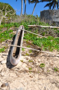
Here is the photo of a Pōpao, one of the Tongan canoes. The boat is no longer intact, but notice the carved wooden hull.
The Kalia
Voyaging canoes improved over time; however, the largest of them all was the Tongan kalia. In the late 18th century, the kalia, a double-hull voyaging canoe was built reaching up to 35 meters in length. The hulls were of unequal length with a moveable, single mast. They were known to carry more than 100 men and today they are thought to have been the fastest Polynesian voyaging vessel around.
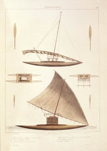
Traditional kalia vessel design; one of the fastest vessels of Polynesian navigation.
The Fijians sailed a similar vessel called the drua and the Samoans sailed the alia. It is uncertain who created the first of these large canoes. Some believe that the kalia was a gift from Micronesia. Others believe that the boats came from a mix of Fijian, Samoan, Tongan, and Micronesian construction.
Today
Although traditional Polynesian navigation and seafaring is rarely used today, there are some organizations around Tonga and throughout Polynesia that still keep the tradition alive. Some organizations have built replicas of the old kalia style vessels. Some of these vessels are used for tourism, providing sailing cruises, while others sail these replica vessels without using modern technology to try and understand what it would have been like without modern navigation and to revive traditions that otherwise would be lost in the winds.
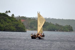
A tour boat in Vava’u as a replica of a Polynesian vessel.
Photos by: 2,4 Amy Heemsoth;
1 http://upload.wikimedia.org/wikipedia/commons/9/93/Pacific_Culture_Areas.jpg;