search-icon
Mapping the Seafloor

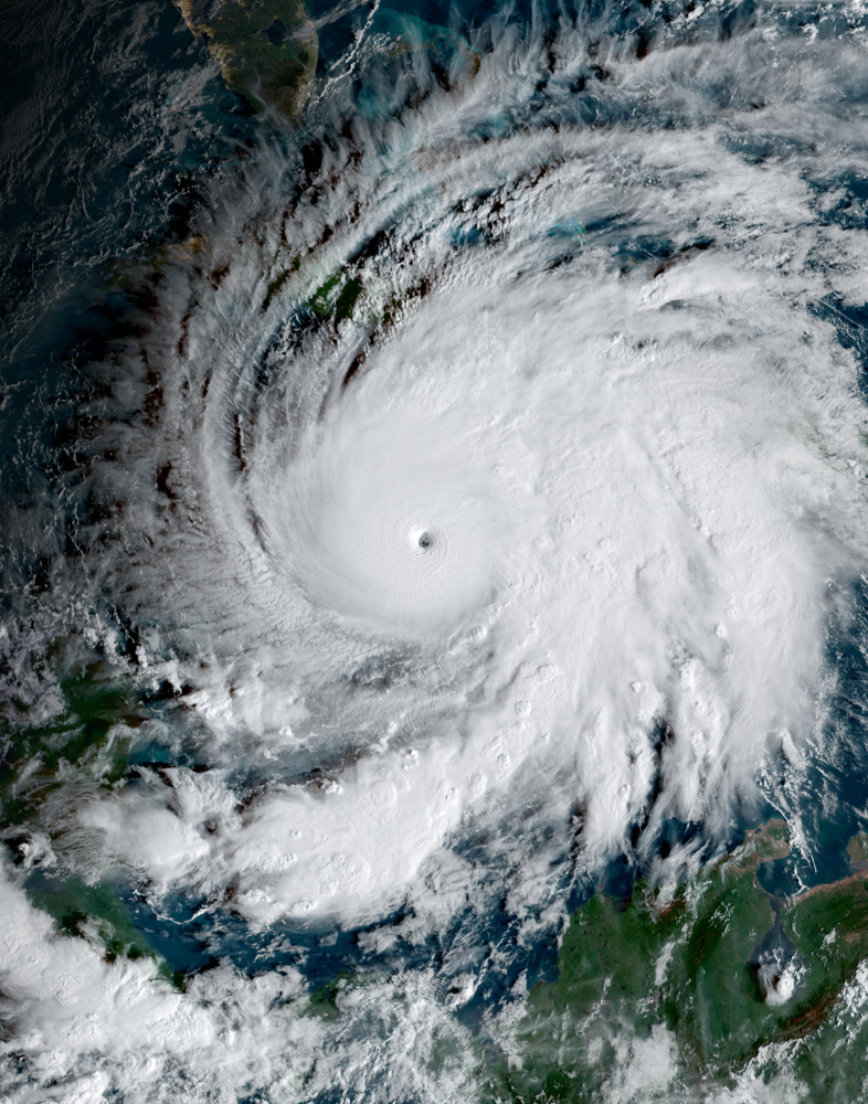
The first site in the Society Islands to be visited in French Polynesia is Mopelia (Maupihaa). This coral atoll has a well-developed reef encircling a lagoon in which numerous bommies occur. Islands sit atop the reef and host sea bird colonies while sea turtles use the beaches for nesting grounds.

Dr. Serge Andrefouet on his way to meet with local fisherman to request permission for the researchers to work around the atoll.


Under the water’s surface, impressive numbers of coral colonies inhabit the outer slope of the reef before it drops off into deep waters. Even the shallow reef flat supports a diverse array of life.

The Process of Seafloor Mapping

One of the Global Reef Expedition’s goals is to create benthic habitat and bathymetric maps of the remote locations visited by the researchers. To accomplish this, researchers must go through the process of seafloor mapping. The ground-truthing team, consisting of Dr. Sam Purkis and doctoral student and Living Oceans Foundation Fellow Jeremy Kerr, surveys the water depth with an acoustic depth sounder and gathers video and digital pictures of the landscape to record the marine habitats present in the area. They incorporate this information into the map-making process via statistical models combining the ground-truth data with satellite imagery, which was acquired prior to field research. The resulting geospatial products show the distribution of marine habitats and the seafloor topography.

Prior to the maps’ completion, the ground-truthing team develops a general sense of site’s landscape characteristics. For example, Mopelia has three main landscape features: a lagoon, a reef flat, and a reef slope.

A WorldView-02 image of Mopelia showing the reef’s geomorphological features. This information becomes part of the seafloor mapping process.

The central lagoon is predominantly filled with muddy sediments and isolated coral bommies. It ranges in depth from 5 meters (16 feet) to 35 meters (113.4 feet). The reef flat is no deeper than 3 meters (9.5 ft) and contains sand, macroalgae, and coral rubble. This is where the islands are located. One can also find exposed reef framework where coral skeletons, clam shells, and cementing algae have been incorporated into the reef matrix.

Exposed reef framework with coral colonies integrated into the reef matrix and held in place by cementing algae.


The reef slope begins just below the water’s surface and slopes to depths of 40 meters (130 ft) before quickly dropping off. This area has much greater live coral cover than any other habitat.

Live coral colonies on the reef slope.

Seafloor Mapping of Society Islands, French Polynesia

The landscape observed at Mopelia in both the satellite imagery and through field observations reflects a recurring theme in geologic studies of coral reefs. The overall structure formed by reef growth over millennia resembles a bucket. The outer edge, where coral and other calcifying organisms grow most vigorously, aggrades quicker than the inner portion of the platform, which slowly fills with sediment. Over time, the different aggradation rates result in a marked difference in water depth throughout the atoll leading to the bucket shape. Even though this phenomenon occurs at many locations, the resulting seafloor topography can vary substantially and the causes for the different expressions are not totally clear. Additionally, it occurs at multiple scales. For example, colonies and bommies can take the same shape where the top and center part of the structure is covered in algae while the edges contain live coral and continue growing. The information gathered during this mission will help illuminate the factors driving this process.

A coral colony in which the center has died and been covered in sand while the edges continued growing.


(Photos/Images by: Jeremy Kerr)

To follow along and see more photos, please visit us on Facebook! You can also follow the expedition on our Global Reef Expedition page, where there is more information about our research and team members.

Related Posts

After the Storm: Standing with Our J.A.M.I.N. Family in Jamaica

There are moments in this work that feel heartbreakingly familiar.

Two weeks after we completed our Jamaica Awareness of Mangroves in Nature (J.A.M.I.N.) programming, Hurricane Melissa made landfall. A powerful Category 5 hurricane, Melissa is now tied with Hurricane Allen in 1980 for the strongest winds ever recorded in an Atlantic storm. Like Hurricane Dorian, which devastated The Bahamas in 2019, Melissa will be remembered as one of the strongest hurricanes on record in the region.

For 11 years, the University of the West Indies Discovery Bay Marine Laboratory and William Knibb Memorial High School have been more than program partners. They have welcomed us into their classrooms and labs, shared meals and laughter, and committed themselves to educating their students about mangroves and coastal resilience. These colleagues and students are not distant collaborators. They are family.

And they were hit hard…

Read More

B.A.M. Turns 10: A Year of Milestones, Resilience, and Growth

The 2025–2026 academic year was one of those defining years for our Bahamas Awareness of Mangroves (B.A.M.) and Jamaica Awareness of Mangroves in Nature (J.A.M.I.N.) programs. It was a year marked by celebration, challenge, growth, and powerful full-circle moments, and a reminder of why mangrove education matters.

In The Bahamas, B.A.M. reached a major milestone: ten years of partnership and environmental education in Abaco. Since 2015, in collaboration with Friends of the Environment, we have worked alongside Patrick J. Bethel High School and Forest Heights Academy to bring hands-on mangrove science into classrooms and into the field. This year, we were proud to expand the program to S.C. Bootle High School, increasing access for students who live…

Read More
Privacy Overview

This website uses cookies so that we can provide you with the best user experience possible. Cookie information is stored in your browser and performs functions such as recognising you when you return to our website and helping our team to understand which sections of the website you find most interesting and useful.  You can view our complete Privacy Policy here.

Strictly Necessary Cookies

Most of our cookies are used to improve website security and reduce spam. These cookies should be enabled at all times. They also enable us to save your preferences for cookie settings.

3rd Party Cookies

This website uses Google Analytics to collect anonymous information such as the number of visitors to the site, and the most popular pages. Keeping this cookie enabled helps us to improve our website.