Focus for today:
What types of islands are the Farasan Islands?
Target key stage:
Key Stage 4: National Science Curriculum, Dual Award, Sc2, 4a: variation arises from genetic causes, environmental causes and a combination of both.
Key information:
Have you ever wondered where islands come from? Well, there are several types of islands and they can be classified according to their position relative to the plates and their genesis. The best known, and maybe most spectacular types of islands, are oceanic islands. They form on top of oceanic plates and their genesis is triggered by so-called hot-spots. These are more or less static magmatic plumes in the earth’s mantle (the region where the rocks are liquid, i.e. magma) that upwell underneath the oceanic crust and, much in the fashion of a blow-torch, burn a hole into it. At this location, magma pours out to form volcanoes. These are usually of rather gentle morphology, and called shield volcanoes. The tips of these volcanoes can break the ocean’s surface – islands like the Hawaiian islands, or Tahiti and Bora Bora are born. Due to sea-floor spreading at the mid-oceanic ridges, the oceanic plates move and the volcanic oceanic islands move away from the hotspots. This causes the islands to lose volcanic activity, and eventually they sink under the sea. Thus, entire island chains are formed. Again, the Hawaiian islands are a good example.
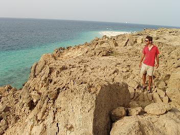
A fault on one of the Farasan Islands
Other types of islands are formed on top of platforms (which themselves can be the results of hot-spot volcanism, or be attached to a continental margin, like here in the Farasan Islands) by sedimentary processes. They can be formed during sea-level lowstands (like the islands in the Bahamas, which are essentially sand dunes heaped up when sea-level was low and the entire platform exposed) or during highstands (like the Florida Keys, which were coral reefs when sea-level was 6m higher than today 125,000 years ago). Many of the smaller islands in the Farasan islands are sand shoals that are simply sand washed together by ocean currents. The Farasans are a small carbonate platform sitting on evaporites (rock-salt formed during the repeated evaporation of the Red Sea during the Miocene period). Due to the extension (widening) of the Red Sea, much pressure is exerted on its sides, which led to faulting of the platform and to tilting of the fragments. The exposed edges form some of the high islands. Other islands are formed by rising saltdomes, which originate from the evaporite layers. Since most evaporites have a lower density than the overlying carbonate (limestone) rocks, they are able to form fingerlike intrusions that push upwards. Since also overlying carbonate layers are pushed upward, small islands are formed.
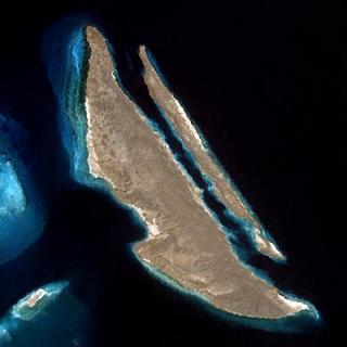
Sarad Island, split by a fault
Thus, in the Farasan islands we observe three different types of islands created by three different processes: small, sandy islands formed by currents; round islands with gentle morphology formed by salt diapirism; and high islands with abrupt morphology formed largely by faulting.
Despite being located in the sea, none of the Farasan islands are truly oceanic, since geologically they are part of the Arabian plate margin.
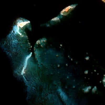
Sand shoals (bottom and left) and raised islands (top right)
Question for students/food for thought:
Do you live on an island, and do you know how it was formed? What geological processes have occured locally to you to form your current environment?
Additional information:
The science team are very excited today as their extra supply of underwater paper has arrived. An underwater paper crisis was quickly rectified by Godfrey Moore of ‘ICI Imagedata’, UK. 400 sheets of underwater paper was dispatched from UK on 10th May and arrived to our shore-based team address on 15th May. The paper reached the Golden Shadow today via the sea-plane! Our data recording certainly would have been rather soggy without it… thanks Godfrey!

