Focus for today:
Farasan Earthquakes (Earthquakes in the Farasan region.)
Target key stage:
Key Stage 4: National Science Curriculum, Dual Award, Sc2, 4a: variation arises from genetic causes, environmental causes and a combination of both.
Key information:
The Farasan Islands lie on the Arabian continental shelf and are largely composed of ancient coral pavement. In many cases, the old corals are still clearly visible in the island surfaces. The fossil coral platforms have been uplifted by faulted blocks of coral limestone which were originally formed in ancient seas (up to several million years ago). The rocks have been lifted up from below by giant domes of salt (commonly termed diapir’s) that are the product of intense evaporation when the Red Sea was cut off from the Indian Ocean in the Miocene epoch five million years ago.
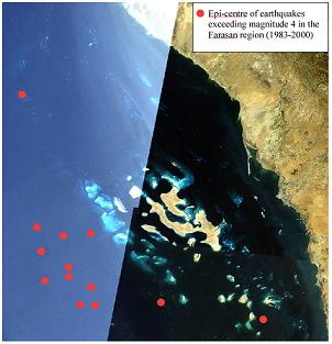
Farasan Earthquakes > magnitude 4 (1983-2000)
With such an active geologic history, the Farasan region is no stranger to both earthquakes and volcanoes. In fact, there are reliable reports of volcanic eruptions in the vicinity of the port of Gizan approximately six hundred years ago. Farasan earthquakes are a far more common occurrence and it is the feeling of the Science Team aboard the Golden Shadow that quakes may in part be responsible the architecture of the marine landscape. In particular, the flanks of the sub-marine platforms on which the team have been researching are characterised by steep sandy slopes, which lie at their angle of repose. This means that the slope would fail and slump, should the angle be increased. Reef platforms typically become hardened by coral growth and therefore can exceed the angle of repose for loose (termed unconsolidated) sediment. It is therefore suspected that the platform slopes do not have ample time to stabilise between earthquakes, and the slopes remain unconsolidated and largely devoid of coral growth.
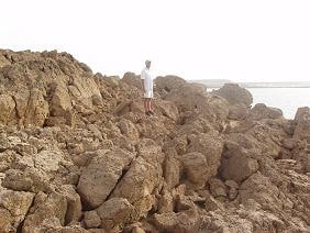
Fractured reef rock that is likely caused by Farasan earthquakes
Records for quake activity in the region indicate thirteen Farasan earthquakes exceeding magnitude five in 1988 and several large tremors throughout the nineties. To investigate the slope hypothesis the Science Team used the ROV to dive down to depths exceeding sixty metres to search for evidence that periodic quakes de-stabilise the flanks of the platform, shifting blocks of coral from their life position in the shallows, and transporting them down-slope. At the base of the slope, the ROV did indeed find several small coral blocks which lend some credence to the hypothesis. The Science Team will focus the ROV operations in the coming days to further investigate the base of the platform slope to shed light on the bank formation and stability.
Question for students/food for thought:
Is the area in which you live subject to periodic earthquakes? Don’t forget that they may be very minor so that you don’t even feel them occur. Where would you find out about this and what precautions should be taken when people choose to settle in areas prone to tremors?