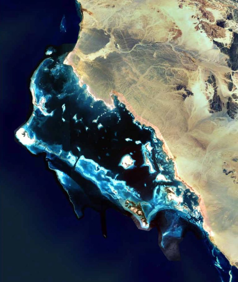
Mapping the World’s Coral Reefs
Creating the largest and most detailed collection of coral reef maps ever made
Mapping the World’s Coral Reefs
Creating the largest and most detailed collection of coral reef maps ever made
About the Project
Mapping the World's Coral Reefs
The Khaled bin Sultan Living Oceans Foundation (KSLOF) is working with partners to create maps of all the coral reefs in the world, providing critical information that can inform conservation strategies and help preserve these vital ecosystems. We have already created the world’s largest collection of high-resolution, ground-truthed coral reef habitat and bathymetric maps, pioneering new satellite mapping technologies to do so along the way. Now, our collaboration with NASA takes these efforts to an entirely new level, working together to build a global map of coral reefs, helping us identify which reefs need to be protected—before it’s too late.
OUR HISTORY OF MAPPING
The Global Reef Expedition
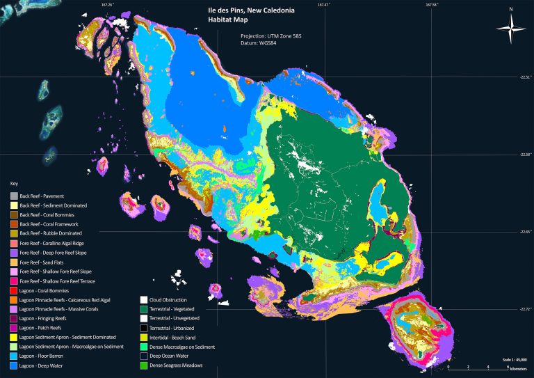
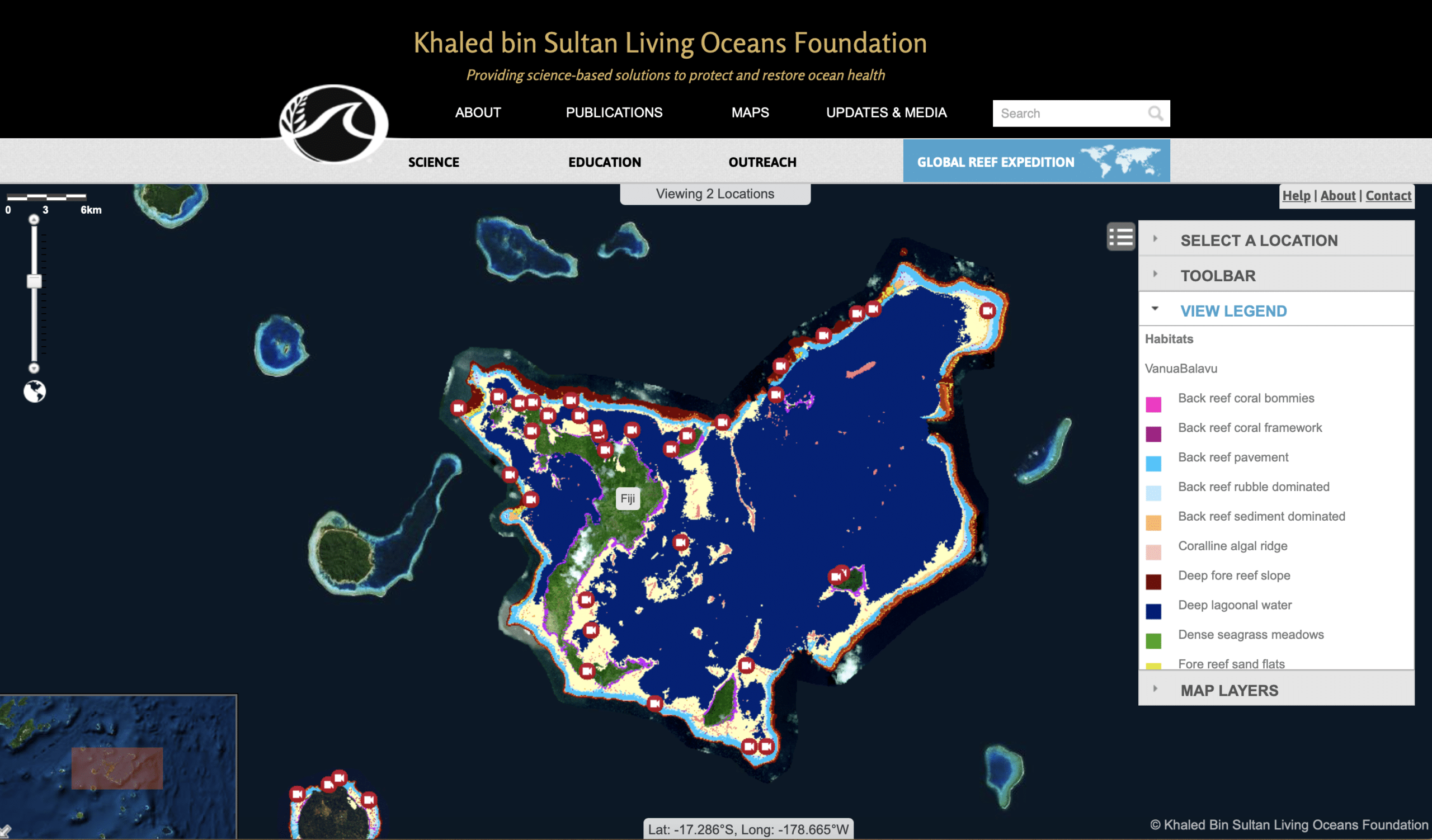
The Global Reef Expedition, one of the largest coral reef surveys in history, circumnavigated the globe, mapping and surveying coral reefs in the Atlantic, Pacific, and Indian Oceans as well as the Red Sea. Over ten years, we gathered data on over 65,000 square kilometers of coral reef habitat—around one-fifth of the world’s coral reefs.
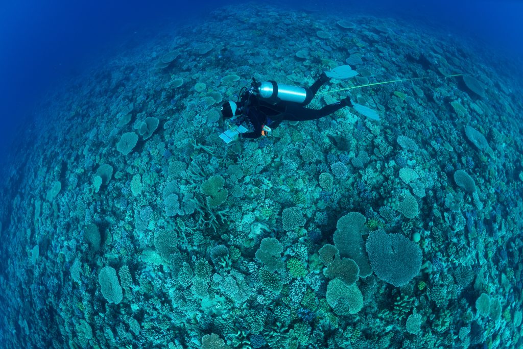
To make this possible, we developed new technologies to map large areas of coral reefs accurately and efficiently. Coral reefs are often located in remote, hard-to-reach areas, and the traditional methods of surveying them, like SCUBA diving, are expensive and time-consuming. By combining satellite imagery with field surveys and cutting-edge remote sensing technologies, our team was able to create high-resolution, detailed habitat and bathymetric maps of over 1,000 coral reefs around the world.
These maps, now part of the World Reef Map, offer a comprehensive view of coral reef distribution and structure in over 12 countries across the globe. The map is an invaluable tool for scientists, governments, and conservation organizations, providing critical information needed to protect and preserve coral reefs for future generations.
Learn more about how these maps were made in our film Mapping the Blue.
Request the Use of Our Data
The Living Oceans Foundation provides opportunities for scientists, governments, and conservation organizations to use our data to protect coral reefs and other coastal marine ecosystems. If you are interested in using our data to support your marine conservation initiatives, we invite you to fill out a data request form to access these valuable resources.
CURRENT PROJECT
Partnering with NASA to Accelerate the Mapping of the World’s Coral Reefs
In 2021, KSLOF formed a partnership with NASA’s Ames Research Center in California to accelerate the global mapping of coral reefs. Through a Space Act Agreement, NASA now has access to our high-resolution maps, which will be used to train their NeMO-Net neural network to create even more detailed and accurate global coral reef maps.
By using data from the Global Reef Expedition, NASA’s NeMO-Net program utilizes satellite imagery, advanced imaging technologies, and supercomputers to monitor and map coral reefs at an unprecedented level of precision. This collaboration will allow scientists to monitor many aspects of coral reef health remotely, without the need for time-consuming and costly field surveys.
We expect to release these enhanced maps to the public next year, giving conservationists and environmental managers worldwide the insights they need to protect coral reefs from ongoing threats.
How You Can Help
Help advance our understanding of coral reefs by playing NeMO-Net, a citizen science iPad game developed by NASA. In the game, players help classify and map coral reefs by painting 3D and 2D images of coral. Your contributions directly feed into NASA’s neural network, improving their mapping accuracy.
Partners
NASA's Ames Research Center

In 2021, the Khaled bin Sultan Living Oceans Foundation signed a Space Act Agreement with NASA’s Ames Research Center, formally partnering to help create the first comprehensive and reliable global map of coral reefs. By sharing our ground-truthed coral reef habitat maps from the Global Reef Expedition, NASA is using this data to train its NeMO-Net neural network and map reefs around the world from space. This cutting-edge collaboration combines satellite imagery, high-performance computing, and coral reef science to generate precise maps that empower researchers and decision-makers to monitor reef change over time and take action to protect these vital ecosystems on a global scale.
University of Miami
The University of Miami has been a key scientific partner of the Khaled bin Sultan Living Oceans Foundation since the launch of the Global Reef Expedition. Together, we created the world’s largest collection of high-resolution coral reef habitat maps, providing an essential baseline for reef monitoring and management. Our ongoing collaboration includes developing a global coral reef health index and associated educational resources, and conducting cutting-edge research on reef resilience in the face of climate change. This partnership continues to advance the science needed to protect and restore coral reefs around the world.
Aircraft Center for Earth Studies (ACES)
The Aircraft Center for Earth Studies (ACES), led by Dr. Ved Chirayath, focuses on science-driven sensing and technology development for next-generation instruments that help us better understand our world and benefit humanity. ACES operates in the University of Miami’s Department of Ocean Sciences (OCE) with a primary focus on developing novel instrumentation and information systems to advance Earth Science objectives. The Living Oceans Foundation collaborates with ACES on their coral reef mapping efforts, including helping to verify the accuracy of their advanced fluid lens drone-mapping technology with underwater observations.
Atlases
To ensure our coral reef maps are accessible and useful to decision-makers, the Khaled bin Sultan Living Oceans Foundation published regional atlases that compile our scientific findings and high-resolution habitat maps into a single, easy-to-use reference. These atlases are designed to support marine managers and government officials in making informed decisions about coastal planning and conservation.
Scientific Publications
The Khaled bin Sultan Living Oceans Foundation has helped push the boundaries of coral reef science by developing and applying innovative mapping technologies. Our research has resulted in dozens of scientific and peer-reviewed publications that explore new methods for mapping coral reefs and apply these tools to better understand reef structure, health, and distribution. These publications reflect our ongoing commitment to advancing the field of marine science and making data accessible for conservation. Explore our mapping-related publications below.
Anna C. Bakker, Arthur C.R. Gleason, Alexandra C. Dempsey, Helen E. Fox, Rebecca H. Green, Sam J. Purkis, (2024). “Remotely sensed habitat diversity predicts species diversity on coral reefs,” Remote Sensing of Environment, Volume 302, 2024, 113990, ISSN 0034-4257, https://doi.org/10.1016/j.rse.2024.113990.
Serge, A., Maële, B., Stéphane, G. et al. (2024). “Evaluation of the Allen Coral Atlas benthic habitat map product for New Caledonia using representative habitat observations from a multi-species fishery assessment.” Coral Reefs. https://doi.org/10.1007/s00338-024-02481-0.
Citation: Global Reef Expedition Final Report. Carlton, R., Dempsey, A., Thompson, L., Heemsoth, A., Lubarsky, K., Faisal, M., and Purkis, S. Khaled bin Sultan Living Oceans Foundation, Annapolis, MD. Vol 15.
Latest Updates
Support Our Work
Coral Reef Mapping
Your donations support critical coral reef mapping and conservation efforts around the world. With your help, we can continue to produce high-resolution, scientifically validated maps that inform marine management, guide conservation planning, and protect these vital ecosystems.
As coral reefs face increasing threats from climate change, overfishing, and pollution, accurate mapping is more important than ever. Help us advance this essential work and ensure that decision-makers have the tools they need to safeguard coral reefs for future generations.