Maps
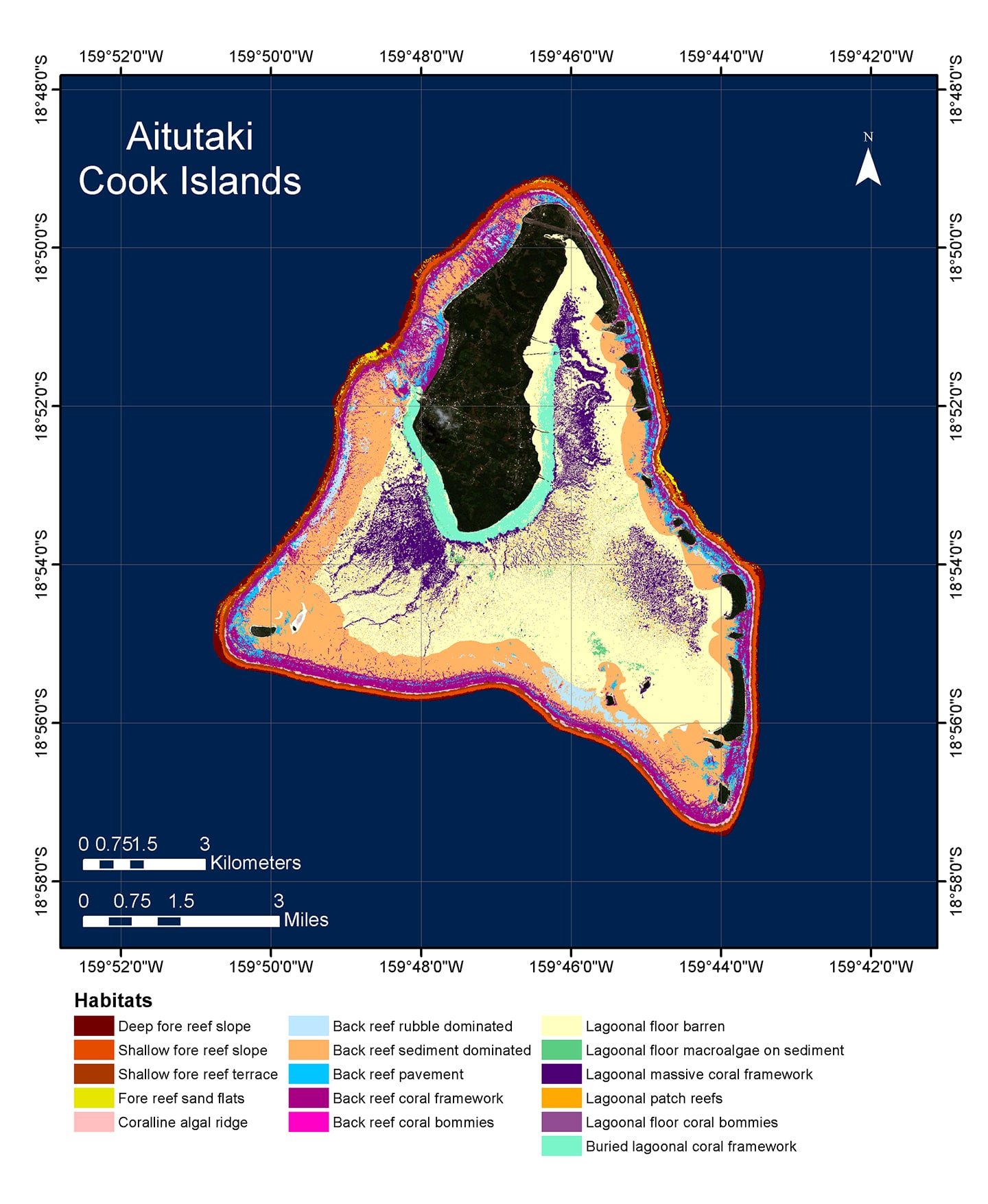 The Khaled bin Sultan Living Oceans Foundation produces high-resolution coral reef habitat maps of previously unmapped, remote coral reef systems around the world. The maps we create are a product of extensive scientific research. We use a process that involves satellite imagery combined with a scientific diver’s inspection of the sea bed, called ground-truthing, to create extremely detailed maps that show the composition of the sea floor which can be made of sand, rubble, live coral or seagrass among other categories. These habitat maps are entered into a GIS so that they can be accessed by anyone with an internet connection.
The GIS data also contains a depth layer, as well as a geo-referenced video layer to allow a virtual diver to explore a precise underwater location on the earth’s surface, and a variety of tools and analytics useful for understanding the habitat composition of a given area.
We do this because the world’s coral reefs are in crisis. Benthic habitat maps are an essential tool in coral reef conservation, providing a snapshot of reefs which scientists and managers can use to track changes in reef composition and structure over time. All the maps we produce from our field research and from the Global Reef Expedition are available to view on our website and can be used for scientific analyses, education, and management.
The production of these maps is made possible by the generous support of Prince Khaled bin Sultan, who won the prestigious Peter Benchley Award for this work exploring and creating the first detailed maps of some of the world’s most remote coral reef ecosystems.
World Reef Map
Our World Reef Map is a global, online, interactive map that allows users to explore all of the coral reefs we have ever surveyed and mapped. This award-winning map is the result of years of work by an extended team of dedicated scientists and many months of field research in remote regions of the world. The Foundation has made these coral reef habitat maps available to the public in this online platform, and the GIS data that this map is built upon is available for governments and conservation organizations to use in their efforts to protect and conserve coral reefs.
Atlases
Our Atlases contain detailed habitat maps along with a summary of our findings on the health and resiliency of coral reefs in a region. We publish an Atlas as the final product of our coral reef research in a region. Hard copies are distributed to our partners, government officials, local leaders, and local conservation organizations. Digital versions of our Atlases are available on our website.
Our maps are made in partnership with Dr. Sam Purkis and his remote sensing lab at the University of Miami’s Rosenstiel School of Marine and Atmospheric Science.
Underwater Street View
We invited XL Catlin Seaview Survey to join us on the Global Reef Expedition in the Solomon Islands to use their custom underwater camera to take stunning 360-degree imagery of the reefs. The virtual dive they created with footage of Marovo Lagoon – the largest saltwater lagoon on the planet – is now available for anyone to explore on Google Street View.
To learn more about mapping research, watch 360⁰ Solomon, a film we produced about our partnership with XL Catlin Seaview Survey and how we collected imagery and data of coral reefs in the Solomon Islands.