Habitat Mapping
Combining satellite imagery with information gathered from our benthic habitat surveys and geo-referenced photos and videos. Our detailed habitat maps of coral reef ecosystems provide a comprehensive snapshot of life on a reef in one place and time.
Half the world’s coral reefs have been lost in the past 40 years. Without basic baseline information, such as where reefs are located, it is challenging to mount a response to the reef crisis on the global scale at which it is occurring. To combat this lack of baseline data, the Khaled bin Sultan Living Oceans Foundation has created detailed habitat and bathymetric maps of the seafloor in many of the places we visited on the Global Reef Expedition. So far, these maps cover over 65,000 km2 of shallow-water marine habitats in 11 countries, making this the largest collection of high-resolution coral reef maps ever made.
Reef Maps & GIS
We gather high-resolution satellite and aircraft imagery, and collect data in the field, to create habitat and bathymetric maps of the ocean floor. We combine them with other geo-referenced data layers in a Geographic Information Systems (GIS) database to create a map of the area. GIS combines cartography, statistical analysis, and database technology to capture, store, visualize, analyze, and interpret data. This allows us to reveal relationships, patterns, and trends through habitat mapping.
These types of GIS maps can be extremely useful to policymakers and conservation organizations developing management strategies to ensure the long-term health of coral reefs and associated shallow-water marine ecosystems. We work with local governments to ensure the GIS data and seafloor habitat maps we create will be relevant and useful to them.
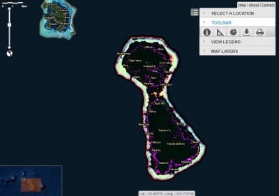
World Reef Map
Our World Reef Map is a global, online, interactive map that allows users to explore all of the coral reefs that we have ever surveyed and mapped. This award-winning map is the result of years of work by an extended team of dedicated scientists and many months of field research in remote regions of the world.
These web–based maps allow those without access to professional GIS software to have easy access to the Foundation’s geospatial products for viewing and querying. We also further compile the map products into richly-illustrated atlases which are available to download from our website.
Beyond making the reef maps available to the public in this online platform, the Foundation shares the underlying data with governments and conservation organizations so it can be used to protect and conserve coral reefs. For more information regarding specific data requests and downloads please contact the Foundation’s Director of Science Management, Alex Dempsey, at [email protected].
Ground Truthing
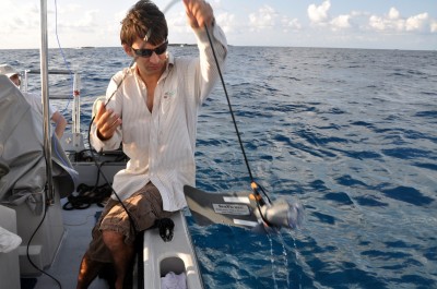
Ground truth refers to information provided by direct observation on the ground, as opposed to information provided by inference using remote sensing. Ground-truthing takes many forms, from simple visual examination of the seabed to SCUBA diving and snorkeling to high-definition video surveys and spectral and acoustic measurements carried out in the field. The Foundation deployed all these methods during the Global Reef Expedition. Although maps can be made without them, ground-truth observations collected in the field are central to developing robust map classes, guiding the mapping itself, and, when kept independent from these tasks, quantifying map error. The more intense the ground-truth survey is—the better constrained the final product will be. The Foundation placed a very strong emphasis on the ground-truthing of both the habitat and bathymetry maps, collecting tens of thousands of seabed observations for the former, and tens of millions of sonar soundings for the latter.
Data Layers
Additional “layers” of data are available on some of the Foundation’s maps. For example, many of the maps include representative video clips, acquired in the field, depicting the various seabed communities as they would be encountered by a diver.
For most regions, we have also produced a map of “optical bathymetry.” These are cost-effective maps of relative water depths in coral reef ecosystems which we have validated with depth measurements taken during ground truthing. While these optical bathymetry products are not suitable for navigation, they are useful for scientific interests and for resource management applications.
Related Publications:
-
2024
Remotely sensed habitat diversity predicts species diversity on coral reefs
Published in Remote Sensing of Environment Abstract The ability to map coral reef biodiversity from orbit would greatly advance marine spatial planning. Presently, reef biodiversity is measured in situ by divers, but this method is inefficient and expensive. Remote sensing techniques …
-
2021
Global Reef Expedition Final Report
The Global Reef Expedition Final Report summarizes the findings from our 10-year research mission to survey and map coral reefs across the Atlantic, Pacific, and Indian Oceans as well as the Red Sea. The Expedition involved hundreds of research scientists …
-
2019
High-resolution habitat and bathymetry maps for 65,000 sq. km of Earth’s remotest coral reefs
A study from scientists at the Khaled bin Sultan Living Oceans Foundation and the University of Miami offers a new way to accurately map coral reefs using a combination of Earth-orbiting satellites and field observations. Using this new method, the scientists mapped over 65,000 km2 of coral reefs and surrounding habitats–by far the largest collection of high-resolution coral reef maps ever made.
-
2019
National-scale marine bioregions for the Southwest Pacific
This scientific paper, by KSLOF scientists Alex Dempsey and Sam Purkis, shows how they used data-based methods to develop the first comprehensive oceanic and marine bioregions for the South Pacific. These marine bioregions enable the design of ecologically representative national marine protected areas in Pacific nations.