


This website uses cookies so that we can provide you with the best user experience possible. Cookie information is stored in your browser and performs functions such as recognising you when you return to our website and helping our team to understand which sections of the website you find most interesting and useful. You can view our complete Privacy Policy here.
Fact Friday
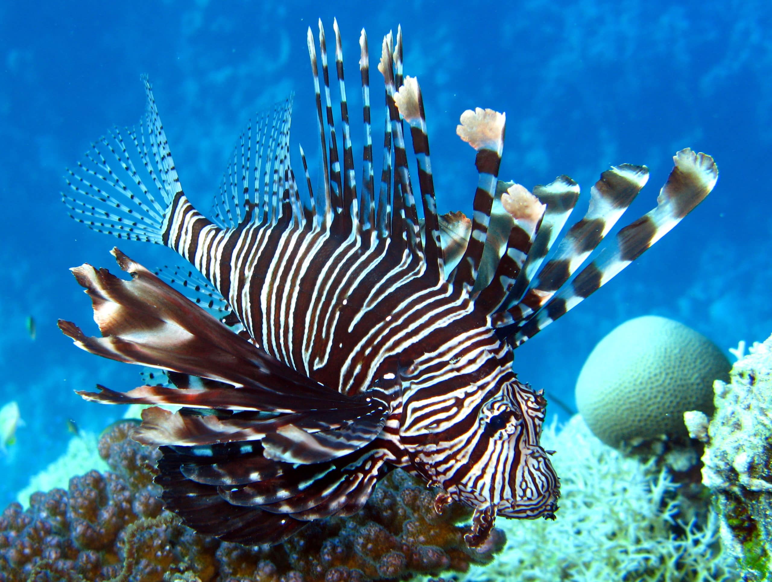
Although lionfish are native to the Indo-Pacific, they are an invasive species that has established populations in the Caribbean and the Gulf of Mexico. These fish pose a threat to marine ecosystems, as they have few natural predators and a voracious appetite. They are difficult to eradicate because of their large unchecked populations, their ability to hide, and venomous spines.
Photo Credit: Andrew Bruckner


REEF TYPES
The ocean covers approximately two-thirds of the Earth’s surface. The other third consists of continents and islands. In the late 1800’s, due to advancements in technology, scientists began studying more of the ocean; however, most of it remains unexplored today. Oceanography is a branch of science that studies the ocean. It covers a wide range of topics including ocean circulation, carbon cycle, plate tectonics, geology, bathymetry, chemical and physical properties of the ocean, the study of ecosystems, and so much more. In this unit on reef types, we will learn about bathymetric features and how this topic relates to coral reefs.
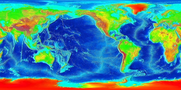
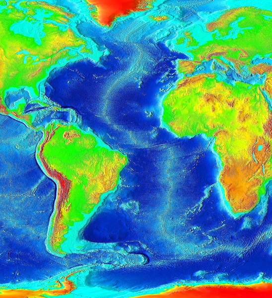
Bathymetry is the study of the depth of underwater structures on the floor of lakes and the ocean (figure 10-1). Just like the topography (physical features and shape of the Earth) on land, the ocean contains different physical features that form underwater mountains, plateaus, plains, volcanoes, trenches, and canyons.
Figure 10-1. Bathymetric and topographic map of Earth

BATHYMETRIC FEATURES OF THE OCEAN FLOOR
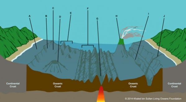
We will now look at the bathymetric features of the ocean floor (figure 10-2).
Earth’s crust is the outermost layer of the Earth. It consists of continental and oceanic crust. Continental crust is the layer, which forms continents; it extends all the way out to the continental shelf in the ocean. Oceanic crust is the layer that forms the surface of the ocean basins. The continental margin separates the continental crust and oceanic crust (see Unit 12: Reef Formation, coming soon).The continental margin is made up of the continental shelf, continental slope, and continental rise.
The continental shelf (A) is an area that gently slopes from continents (or around islands) and extends to the continental slope. In comparison to the open ocean, the shelf is quite shallow, only a few dozen feet (tens of meters) deep, whereas, the open ocean can be tens of thousands of feet (thousands of meters) deep. The width of the continental shelf also varies. For instance, the widest shelf in the world is in the Arctic, called the Siberian Shelf. It measures approximately 932 miles (1,500 kilometers) in width! Other places like West Palm Beach, Florida have an extremely narrow continental shelf extending less than 1.25 miles (2 kilometers) in width.
The continental slope (B) is an area that transitions from the continental crust to the oceanic crust. This area is between the continental shelf and the continental rise. The continental slope steeply drops off and can reach depths of almost 10,000 feet (3,200 meters).
The area between the continental slope and the abyssal plain is called the continental rise (C). This area is formed by an accumulation of sediment and dead organisms that are transported from the continental shelf and slope by currents that are traveling seaward.
Ocean basins are large geographic regions that are below sea level. They contain features such as abyssal plains, mid-ocean ridges, deep-sea trenches, plateaus, seamounts, and guyots. There are five major ocean basins: the Arctic Ocean, Atlantic Ocean, Indian Ocean, Pacific Ocean, and Southern Ocean.
Figure 10-2. Ocean floor features A) continental shelf, B) continental slope, C) continental rise; D) guyot, E) seamounts, F) mid-ocean ridge, G) rift valley, H) volcano, I) deep-sea trench. J) submarine canyon
Abyssal plains are found between the continental rise and the mid-ocean ridges. It appears to be very flat due to the thick layer of sediment that hides the hills and valleys. Hills that are more prominent and rise up out of the abyssal plain are called abyssal hills. These hills vary in diameter and height; however, they are usually no higher than 1,000 feet (a few hundred meters). They often occur in groups. Abyssal plains and hills are named after the oceanic zone that they occupy – the abyssal zone. This zone ranges from depths of 10,000-20,000 feet (3,000-6,000 meters).
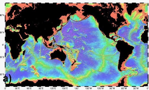
Mid-ocean ridges (F, figure 10-3) are a chain of continuous mountains that line each side of a rift valley. They span across every ocean basin. The mountains can reach heights of approximately 12,000 feet (3,600 meters), and they can even rise above the ocean’s surface. Mid-ocean ridges are the longest feature on Earth, including those of land features. Some even exceed 43,500 miles (70,000 kilometers) in length.
Rift valleys (G) are large depressions in the deep ocean basin that are lined with mid-ocean ridges. This is an area where the seafloor is spreading (where two tectonic plates are drifting apart), causing a valley to form between them. Deep beneath valley, magma emerges, cools, and creates new ocean floor. In Unit 12: Coral Reef Formation (coming soon) we will learn more about this process.
Figure 10-3. Maps of Earth’s mid-ocean ridges a) The yellow areas and b) the red areas show the location of mid-ocean ridges.
Deep-sea trenches (I) are long, narrow asymmetrical depressions that run parallel to continental margins or volcanic islands. They are very deep. The steep side of the trench is toward the land mass. There are often earthquakes because two tectonic plates are coming together and volcanic activity near these regions. The largest number of trenches and volcanic activity can be found near the margins of the Pacific Ocean. This area is referred to as the Ring of Fire.
Fun fact
X

Fun Fact
The Marianas Trench is located in the Pacific Ocean and it is situated between the Northern Marianas Island and Guam – both U.S. dependencies. It is the deepest part of the ocean’s surface, reaching maximum depths of 36,201 feet (11,033 meters)! The trench was created by oceanic-oceanic plate subduction.
In 2009, United States President George W. Bush established the Marianas Trench Marine National Monument, which protects 96,714 square miles (250,487 square kilometers) of submerged lands and waters. This area is not only of importance because it includes the Marianas Trench. It also contains coral reef ecosystems that thrive near volcanic islands. The coral reefs are thought to have very high concentrations of large predators like sharks. This area is also a refuge for sea birds and turtles and it contains a large variety of stony corals.
Check out this cool flythrough of the Marianas Trench (provided by NOAA)
Deep, steep-sided valleys that cut into the sea floor starting from the continental shelf to deep ocean basins are called submarine canyons (J).
Plateaus are elevated large, flat, or nearly flat-topped tables that drop off abruptly on one or more sides.
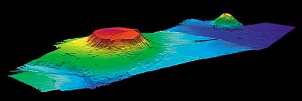
Underwater volcanoes are called seamounts (E, figure 10-4). They are defined as having an elevation of over 3,000 feet (1,000 m) and having a conical shape (IHO 2008). Seamounts are formed by hotspots in the ocean floor, or areas that produce magma that flows from the Earth’s mantle. Magma emerges from the mantle and cools, allowing the volcano to grow larger. Once the seamount moves away from the hotspot, the volcano becomes dormant. Sometimes the seamount grows to be so large that it breaks the surface of the water, becoming an island. This is how the Hawaiian Islands formed. Ocean volcanoes (H) are seamounts that have risen above the ocean’s surface. In Unit 12: Reef Formation (coming soon), we will learn about how atolls can form from seamounts.
When seamounts become an island, waves and wind can erode the top of the seamount. Over time, the top of the island becomes flat. This is known as a guyot (D, figure 10-4). As geologic time passes, tectonic plates move and sea level rises and falls. When these events take place, guyots can become completely submerged.
Figure 10-4. 3D image of Bear Guyot (left) and Physalia Seamount (right) located in the Atlantic Ocean
It’s important to understand the different bathymetric features that make up the ocean floor and how the morphology of these features can change helps scientists to make advances in ocean science. For instance, by studying the bathymetry of the ocean floor, scientists can recognize how coral reefs have formed, how they change over time, and where they could survive in the future with a potential rise in sea level.
Now we are going to learn about the bathymetric features that coral reefs commonly grow on, as well as the different classifications of coral reefs.

CORAL REEF GEOMORPHOLOGY INTRODUCTION
Coral reefs are classified by their geomorphology. Let’s break down the word geomorphology.
geo morpho logy
earth form the study of
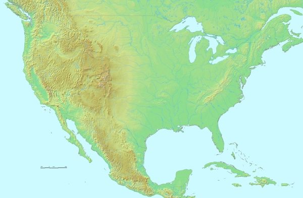
By dissecting the word, we can see that geomorphology means the study of the forms on Earth. More specifically, it means the study of the origin and evolution of the Earth’s topography (figure 10-5a) and bathymetry (figure 10-5b).
Figure 10-5. a) Topographic map of the lower 48 United States; b) Bathymetric map of Atlantic Ocean
Coral reef geomorphology is the study of (Andrefouet 2011):
- distribution (see Unit 7: Distribution);
- reef morphology (shape)
- bathymetry
- reef location in relation to land forms
- processes that control reef formation such as sea level rise and changes in morphology (see Unit 12: Reef Formation, coming soon)
How do we find the bathymetry of the ocean floor and coral reefs? The answer is seafloor mapping. In Unit 21 (coming soon), we will discuss how the seafloor is mapped.
Which bathymetric features can coral reefs grow on? Coral reefs mainly occur near continents or islands. Recall that corals need sunlight in order to survive (see Unit 8: Environmental Conditions) meaning that most corals cannot survive at deeper depths where there is little to no light. Since areas of the continental shelf can be relatively shallow, corals can thrive here, growing around islands and continents.
Coral reefs can also thrive around structures that rise out of the ocean basin. Again, these structures must be in depths that are suitable for corals to survive. Corals can colonize on and/or around structures such as volcanoes, guyots, seamounts, and plateaus.
Over geologic time, the bathymetry of the sea floor changes. We will learn more about why it changes in Unit 12: Reef Formation (coming soon). When these changes occur, the geomorphology of coral reefs can also be altered. That is why there are different geomorphological classifications of coral reefs.

Types of Coral Reef Geomorphology
There are three main types of geomorphology that are used to classify coral reefs: fringing reefs, barrier reefs, and coral atolls.
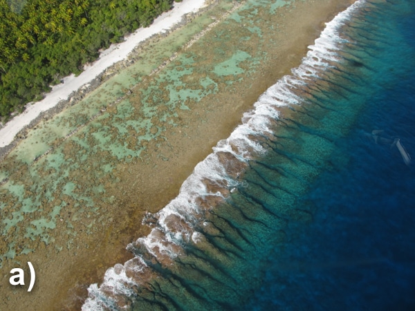
- Fringing reefs (figure 10-6) are reefs that colonize near the shoreline of continents or islands. They do not contain a lagoon between the shoreline and the reef. Since there is no buffer between land and reef, this type of reef is the most susceptible to human impacts such as runoff, human contact, and overfishing. Fringing reefs are the most common of the three types.
Figure 10-6. a) Fringing reef, Society Islands; b) Fringing reef, Mangareva Island, Gambier
Photo Credit: Andrew Bruckner
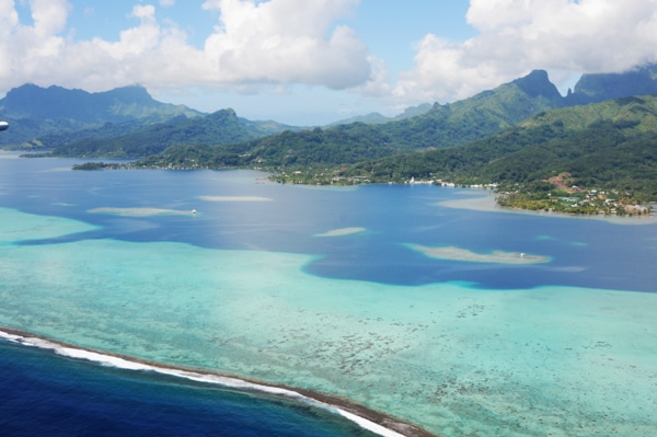
- Barrier reefs (figure 10-7) occur further offshore and run parallel to the shoreline. They are separated from land by a lagoon, and the reef typically grows along the outer edges of the continental shelf. The distance between the land and the reef varies with each individual reef. Although barrier reefs are a common type of reef they are not often found in the Caribbean.
Fun fact
X
Fun Fact
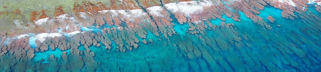
The Great Barrier Reef in Australia is the largest coral reef system in the world. The reef area (132,974 square miles or 344,400 km2) is approximately the size of Japan and it’s so large that it can be seen from space! This reef is actually not one, long, complete, solid reef structure. It is made up of nearly 3,000 individual reefs, 600 islands, and 300 coral cays. Check out this aerial photo that Will Robbins took of the Great Barrier Reef.

Photo Credit: William Robbins
Probably the most famous reef in the world is the Great Barrier Reef in Australia. It is called the Great Barrier Reef because there is a lagoon that separates these reefs from land. This is actually not one continuous reef; it’s considered a reef system. It actually consists of thousands of individual reefs.
Figure 10-7. Barrier reefs, Ra’iātea, Society Islands
Photo Credit: Andrew Bruckner
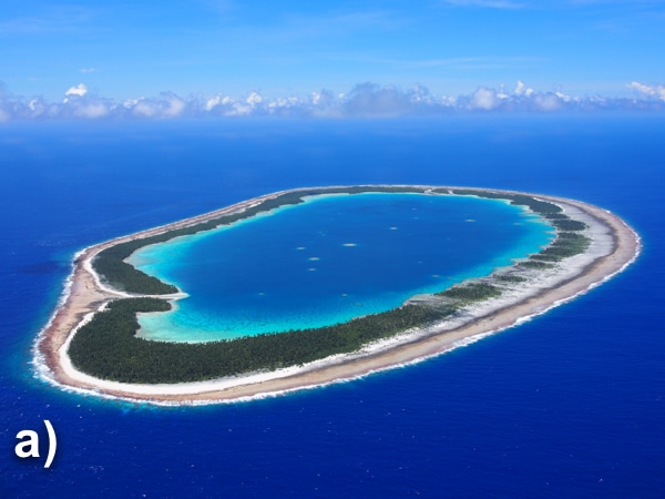
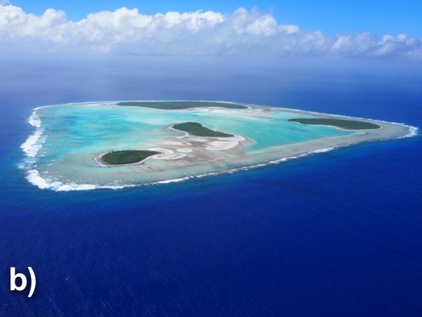
- An atoll (figure 10-8) is either an oval, circular, or horseshoe-shaped coral reef, which contains a coral rim. The coral rim either partially or completely surrounds a lagoon. If the rim is only partial, water from the surrounding ocean will flow in and out of the lagoon through channels that lie between the broken land. If the coral rim is complete, then there will not be water flow between the enclosed lagoon and ocean.
Atolls form from volcanoes. Atolls are not commonly found throughout the Caribbean, when compared to the Indian and Pacific Oceans. This is mostly due to how coral reefs have formed in the Caribbean. We will learn more about atoll formation in Unit 12: Reef Formation (coming soon).
Figure 10-8. a) Maria Est Atoll, Tuamotu Archipelago; b) Maria Oeste Atoll, Austral Islands
Photo Credit: Andrew Bruckner
Fun fact
X
Fun Fact
Did you know that the word atoll is derived from the Maldivian word atolu? The Pacific Ocean contains the greatest number of atolls. In French Polynesia (South Pacific), alone, there are 80 atolls. The largest atoll is believed to be Huvadhu in the Maldives (Indian Ocean) with an area of around 1,081 square miles (2,800 square kilometers). That would calculate to over half a million American football fields but together!
Source: Woodriffe, P. & Biribo, N. 2011. Atolls. In Encyclopedia of Modern Coral Reefs (pp. 1-21). Springer Netherlands.
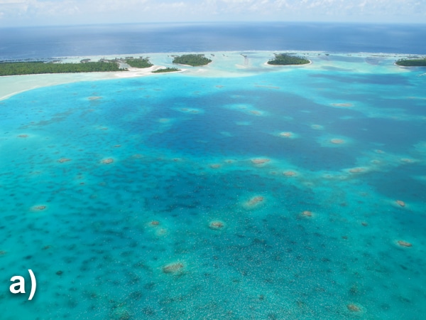
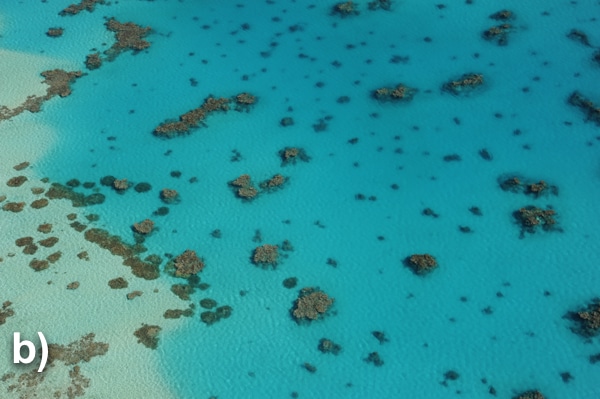
Coral reefs can also be organized into more specific classifications, which helps scientists to further characterize individual coral reefs. For example, patch reefs (figure 10-9) are small, isolated reefs often found in a lagoon or embayment. They vary greatly in size and are often circular. They do not occur in every reef type, or even at all. For example, an atoll may or may not contain patch reefs.
Scientists have identified around 800 different classes of reefs (Andréfouët 2011), including the ones we have learned about here. When identifying the types of reefs, it is not as black and white as it might seem. Corals are continuously growing and changing. Not all coral reefs fit perfectly into these classifications. Sometimes reef systems cannot be classified as one type or the other. Other times they may fit into multiple classifications. In Unit 12: Reef Formation (coming soon), we will talk more about the processes that control reef formation, including why some reefs change classifications.
Figure 10-9. a) Patch reefs, Society Islands, French Polynesia; b) Patch reefs, Austral Islands, French Polynesia
Photo Credit: Andrew Bruckner
Fun fact
X
Fun Fact
Did you know that coral reefs cover an area of 81.585 square miles (212,340 square kilometers), which is only 0.059% of the oceans? This is a relatively small area compared to the rest of the ocean.
Source: Harris, P. T., Macmillan-Lawler, M., Rupp, J., & Baker, E.K. 2014. Geomorphology of the Oceans. Marine Geology 352: 4-24.

ATTRIBUTIONS & CITATIONS
ATTRIBUTIONS
Figure 10-1. By National Oceanic and Atmospheric Administration [Public domain], 12 March 2006 via Wikimedia Commons. https://commons.wikimedia.org/wiki/File:LARGE_elevation.jpg.
Figure 10-2. Adopted by n.a. via Pixgood. http://pixgood.com/ocean-floor-profile.html.
Figure 10-3a). By National Oceanic and Atmospheric Administration [Public domain], 26 September 1996 via Wikimedia Commons. https://commons.wikimedia.org/wiki/File%3AMid-ocean_ridge_system.gif.
Figure 10-3b). By J M Watson [Public domain], 5 May 1999 via Wikimedia Commons. https://commons.wikimedia.org/wiki/File%3AWorld_Distribution_of_Mid-Oceanic_Ridges.gif.
Figure 10-4. By Btermini at en.wikipedia (http://www.photolib.noaa.gov/brs/clind5.htm) [Public domain], 21 March 2007 via Wikimedia Commons. https://commons.wikimedia.org/wiki/File%3ABear_Seamount_guyot.jpg.
Figure 10-5a). By DEMIS BV and uploader [Public domain], 9 November 2010 via Wikimedia Commons. https://commons.wikimedia.org/wiki/File%3AMap_of_USA_topological.png.
Figure 10-5b). By NOAA (http://www.ngdc.noaa.gov/mgg/image/2minrelief.html) [Public domain], 27 November 2006 via Wikimedia Commons. https://commons.wikimedia.org/wiki/File%3AAtlantic_bathymetry.jpg.
CITATIONS
Andréfouët, S. (2011). Reef Typology. In Encyclopedia of Modern Coral Reefs (pp. 906-911). Springer Netherlands.
Hopley, D., Smithers, S. & Parnell, K. (2007). The geomorphology of the Great Barrier Reef: development, diversity, and change. Cambridge; New York, Cambridge University Press.
IHO. (2008). Standardization of undersea feature names: guidelines proposal form terminology (4th ed). International Hydrographic Organization and Intergovernmental Oceanographic Commission, Monaco
